
Leica Cyclone FIELD 360 APK cracked android and iphone version
160 $
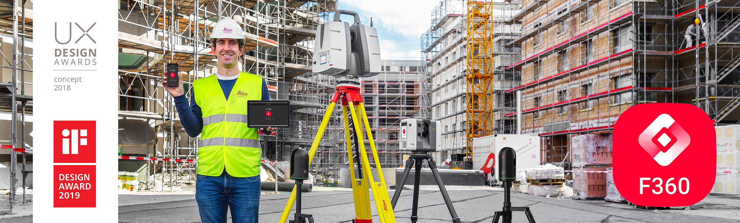
Leica Cyclone FIELD 360 – Mobile 3D Scanning App
Leica Cyclone FIELD 360 is a field-ready 3D laser scanning app for Android/iOS that extends Leica’s reality-capture workflow into the field. It lets surveyors and engineers pair a mobile device with Leica laser scanners (RTC360, ScanStation P/P30/P40/P50, BLK360, BLK2GO, etc.) to capture and pre-register high-precision point-clouds on-site. The intuitive interface makes scanning and data alignment easy for both novice and expert users, with real-time previews, in-field registration, and instant quality checks. Cyclone FIELD 360 then exports enriched, georeferenced point-clouds and floorplans (IFC/DXF) directly to the cloud, seamlessly bridging field capture and office workflows…
Description
Leica Cyclone FIELD 360 v5.2.1 – Mobile 3D Laser Scanning App
Leica Cyclone FIELD 360 is a powerful field-to-office scanning app that “takes field work farther and unites the field-office-cloud reality capture workflow”. Designed for Android and iOS, it pairs with Leica terrestrial and handheld laser scanners (RTC360, ScanStation, BLK360, BLK2GO, BLK2GO PULSE, etc.) to capture, pre-register and analyze 3D point-cloud data on-site. In version 5.2.1, Leica built on the major 5.2 release by adding support for the newest Android 16 operating system and polishing scanner workflows. This update focuses on new scanning modes, expanded compatibility, and stability fixes to keep site surveys smooth and efficient.
Key New Features & Highlights
- Full Point Cloud Data Mode (BLK2GO/BLK ARC): Version 5.2 introduced the ability to toggle full-density streaming for BLK2GO and BLK ARC scanners. Users can now enable or disable “Full point cloud data mode” on each job. When enabled, the scanner sends the entire high-density point cloud to the mobile device for maximum detail; when disabled, it streams a lighter, subsampled cloud to conserve bandwidth. This gives users fine control over data capture. (Note: Enabling full mode can use significant storage on the device, so plan accordingly.)
- Android 16 Compatibility: Cyclone FIELD 360 v5.2.1 officially supports Android 16, ensuring the app works on the latest phones and tablets. Previously, Android 10.0+ (64-bit) was required; now even devices running Android 16 can run the app natively. This future-proofs deployments on cutting-edge hardware.
- Intuitive Field Workflow: The update maintains the app’s ultra-intuitive interface. Field crews still enjoy features like real-time scan previews, one-touch registration of scans, automatic georeferencing, and on-site quality checks (e.g. floor flatness analysis). The new Full Data Mode integrates seamlessly: users can switch modes mid-project and continue scanning without restarting.
- Cloud-Enabled Deliverables: After capture, enriched point-clouds and 2D/3D floorplans can be exported directly from the device and synchronized with Leica’s cloud services. This rapid “field-to-finish” capability was already a highlight and remains fully supported in v5.2.1. Surveyors still benefit from the app’s built-in IFC/DXF exports and easy sharing of registered scans.
- License & Editions: Cyclone FIELD 360 v5.2.1 continues to require an active annual license (Basic, Standard, or BLK Edition) for activation. The update does not change licensing terms, but users should note that advanced features (like Full Data Mode and specialized workflows) may require the higher-tier licenses.
System Requirements & Compatibility
- Android Devices: Requires Android 10.0 or higher on a 64-bit ARM or x86_64 device. The app is optimized for 4+ GB tablets/smartphones. Recommended devices include Samsung Galaxy Tab S8/S9 and Galaxy S22/S23 series. These ensure smooth performance with large point-clouds and complex projects.
- iOS Devices: For Apple users, Cyclone FIELD 360 on iPad/iPhone requires iOS 16 or higher (64-bit, ≥4 GB RAM). Recommended hardware includes iPad Pro 11” (2021/2022) and iPhone 13, 14, 15, 16 series. (First-generation BLK360 scanners still perform best on iOS.)
- Scanner Integration: This release supports Leica’s full range of terrestrial and handheld scanners. The update specifically improves workflows for the BLK2GO and BLK ARC (new Full Data Mode), while maintaining compatibility with legacy devices (RTC360, BLK360, etc.). Remote control via Wi-Fi or Bluetooth works as before, letting users drive scanners and view point-clouds on the device.
- Software Ecosystem: Cyclone FIELD 360 v5.2.1 works with the Leica Cyclone ecosystem: project data is fully compatible with Cyclone REGISTER 360 and REGISTER 360 PLUS (version 2024.0.1 or later). The app can publish directly to Leica’s HxDR cloud for processing in Cyclone Register. Also, the app’s file outputs (e.g. E57, IFC) remain compatible with common engineering and CAD software.
Bug Fixes & Stability Improvements
- BLK2GO/ARC Reliability: Multiple bugs causing app crashes with the BLK2GO and BLK ARC handheld scanners have been fixed. Users reported that connecting and scanning with these devices could crash earlier versions; v5.2.1 stabilizes those connections for long walk-up scans.
- Licensing Issue Resolved: A BLK ARC licensing bug was corrected. Previously some BLK ARC units would erroneously report a license error even when properly licensed; this is now fixed.
- Faster Walk Optimization: The time to create and optimize BLK2GO/ARC “walks” (continuous scans) is greatly reduced. What used to take extra processing time now completes faster, so field teams spend less idle time waiting for data crunching.
- Error Message Corrections: In earlier versions, BLK360 and BLK360 G1 scanners sometimes showed misleading error messages. v5.2.1 corrects those so that any issues (e.g. missing data) are clearly communicated.
- General Stability: A number of miscellaneous bug fixes and performance tweaks are included to improve overall stability. Leica notes that this update “fixes bugs that could cause crashes” and adds “stability improvements” for a smoother user experience.
Workflow Impact: Together, these fixes mean survey teams can rely on consistent, crash-free operation with the BLK2GO/ARC scanners. The ability to record longer walks without interruption boosts productivity, and Android 16 support ensures compatibility with new hardware as older tablets retire.
Interesting Fact
- Full Data Mode vs. Storage: Enabling Full Point Cloud Data Mode can dramatically increase the volume of data collected. For example, a single scan in full mode might create several gigabytes of point-cloud data on the tablet. Leica explicitly warns to plan for this: “Enabling Full point cloud data mode can take up a lot of storage space”. In practice, teams often use full mode only for critical scans where maximum detail is needed, and switch to the lighter streaming mode for routine scans to save space.
Summary
Leica Cyclone FIELD 360 v5.2.1 is a build update that refines the major 5.2 release. Its highlights are the new BLK2GO/ARC full-data mode and Android 16 compatibility, which together enhance data quality and device support. The update also resolves key bugs on BLK2GO/ARC, ensuring long-duration scans no longer crash and licensing works correctly. These improvements make the app more robust for fieldwork: surveyors can capture high-resolution point-clouds or switch to lightweight mode as needed, and trust that Cyclone FIELD 360 will run reliably on modern Android tablets. All other features (in-field registration, floorplan export, cloud sync) remain available as before, continuing to tie the field data seamlessly back to office processing.
This detailed update, along with Leica’s frequent release notes, demonstrates a commitment to evolving the software. By integrating user feedback (bug fixes) and new technology support, Cyclone FIELD 360 ensures that teams using Leica’s scanners have an optimized, future-proof mobile app for reality capture.
View
The high-performance Leica Cyclone FIELD 360 mobile-device app is the perfect field companion for the RTC360 3D laser scanner, the ScanStation P30/P40 and P50, as well as the BLK360 imaging laser scanner. With its intuitive user interface, remote scanner control and on-site point cloud display, navigation is a breeze – even for novice users – with full imagery and point cloud data delivered directly to a tablet using edge computing technology.
Check
Direct data access and visualisation are the foundation for quality control in the field; with Cyclone FIELD 360, automatically pre-registered point cloud data enables users to quickly conduct on-site quality control checks, improves productivity and makes for better-informed decisions in the field. Furthermore, directly publish your captured data from Cyclone FIELD 360 to Leica TruView Cloud to quickly exchange project information prior to import and registration.
Add
For improved interpretation in Leica Cyclone REGISTER 360 post-processing, and to add extra value and information to 3D data, Cyclone FIELD 360 enables on-site tagging of measurements, videos, images, text or voice files to the point cloud geometry simply by using a tablet or smartphone.
★★★★★
Overall, this app has become an indispensable part of our surveying toolkit. Performance is rock-solid now that key crashes and errors have been resolved, so we rarely lose time to technical glitches. The developers clearly refined every detail – from improved BLK2GO connectivity to more efficient scan processing – which shows in daily use. In short, Leica Cyclone FIELD 360 is a top-tier mobile scanning solution: professional, powerful, and developer-friendly. Highly recommended for anyone needing accurate and efficient field data capture.
Rame Volkoleve
Related products
-

PointSense Total Package cracked version
200 $ Add to cart Quick View -
Sale!

Intergraph CADWorx 2017 R1 cracked version
Original price was: 180 $.150 $Current price is: 150 $. Add to cart Quick View -
TachyCAD (Archaeology and Building Survey) cracked
160 $ Add to cart Quick View -

SOCET GXP 4.2.0 cracked full version
160 $ Add to cart Quick View -
Sale!

BERNINA Embroidery Software 7 DesignerPlus cracked version
Original price was: 1,999 $.150 $Current price is: 150 $. Add to cart Quick View -

Intergraph CAESAR II v11 cracked version
120 $ Add to cart Quick View -
Sale!

DESIGN SUITE cracked version
Original price was: 8,000 $.250 $Current price is: 250 $. Add to cart Quick View -
ASAP Pro
150 $ Add to cart Quick View -
Nikon CMM-Manager 3.5 cracked
180 $ Add to cart Quick View -

Lantek Workshop (Manager, Wos, Capture)
150 $ Add to cart Quick View