Description
Powerful and easy to use GNSS data processing software
Trimble® GPS Pathfinder® Office software is a powerful and easy-to-use land surveying software package of GNSS post-processing tools, designed to take GNSS data collected in the field and turn it into consistent, reliable, and accurate GIS information.
Sophisticated data dictionary editor ensures consistency between the field and the office
- Create custom lists of features and attributes for field data collection with the Data Dictionary Editor, or import a data dictionary from a GIS based on its exact data schema.
- Receive prompts in the field to enter specific information into data capture forms, ensuring data integrity and compatibility with the GIS.
- Create conditional attributes that dynamically adapt to previously entered attribute values, for maximum data collection efficiency.
Differential corrections to improve the quality of GNSS data collected in the field
- Use postprocessing to significantly improve the accuracy of data collected in the field all the way down to centimeter level (1 cm / 0.4 inch).1
- Supports the complete Trimble Mapping and GIS GNSS portfolio, as well as associated positioning technologies, such as Trimble H-Star™.
1 Depending on the environment and the GNSS receiver.
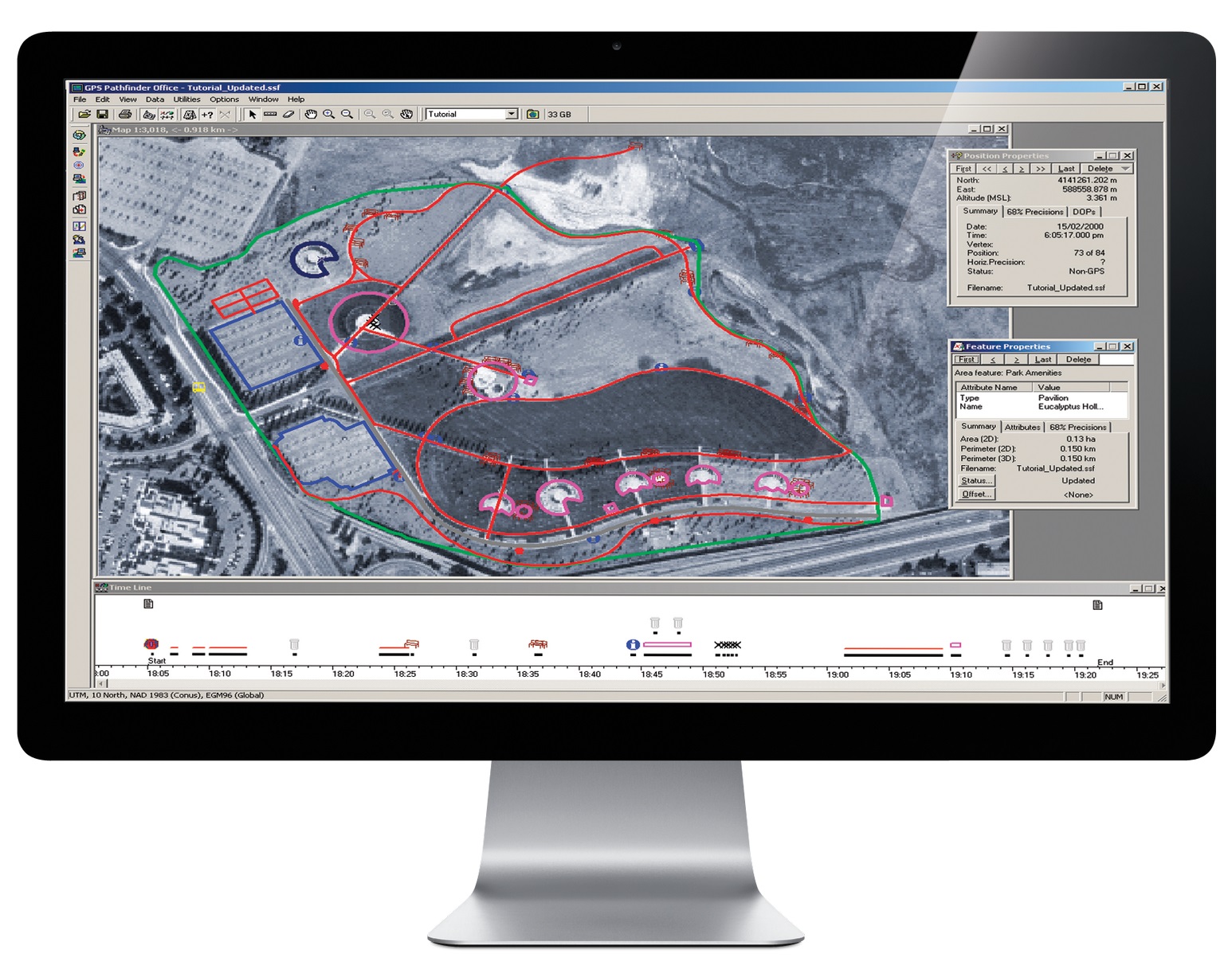
Quality control your collected field data
- Analyze collected features to confirm they are complete and accurate before exporting to a GIS, CAD, or database system. Review and edit GNSS positions and attributes for the highest quality data.
- Collected features can be compared against background datasets such as vector GIS data, aerial photographs or satellite imagery in order to verify accuracy and detect conflicts.
- Background data can be imported to GPS Pathfinder Office from GIS systems, directly from imagery files, or referenced directly from a WMS.
Import and export data to a variety of GIS and CAD formats
- Verify and update GIS data previously collected in the field.
- Import data to GPS Pathfinder Office from a number of GIS and database formats.
- Export collected data and associated metadata to a number of GIS and CAD formats.
- Additional import and export formats supported via Trimble SSF and DDF data format extensions for FME.
Customize TerraSync user interface for simplified field operation
- Use TerraSync™ Studio utility within GPS Pathfinder Office to customize the TerraSync user interface.
- Disable functionality to ensure maximum field productivity and eliminate potential configuration errors.
- View data forms clearly with a customized user interface that speeds up form completion without sacrificing accuracy.
Trimble® GPS Pathfinder® Office software is a
powerful and easy-to-use software package
of GNSS postprocessing tools, designed to
develop GIS information that is consistent,
reliable, and accurate from GNSS data collected
in the field.
Improve the accuracy of GNSS data
Postprocessing with Trimble GPS Pathfinder
Office software significantly improves the
accuracy of data collected in the field all the way
down to centimeter (1 cm / 0.4 in) level. Trimble
GPS Pathfinder Office software supports the
complete Trimble Mapping and GIS GNSS
portfolio, as well as associated positioning
technologies, such as Trimble H-StarTM.
Increase field work efficiency and
productivity
Data can be imported to GPS Pathfinder Office
software from a number of GIS and database
formats, allowing previously collected GIS
field data to be verified and updated. The
software’s Data Dictionary Editor creates
custom lists of features and attributes for field
data collection and supports the development
of conditional attribute data capture forms in
Trimble TerraSyncTM software that dynamically
adapt to previously entered attribute values for
maximum data collection efficiency.
By creating a data dictionary or importing one
from a GIS based on its exact data schema,
GIS administrators can be confident that data
collected in the field will integrate seamlessly
with the GIS repository and that data returned
will be accurate and consistent. In the field,
the data capture form prompts you to enter
specific information, ensuring data integrity and
compatibility with the GIS.
The Trimble TerraSync Studio utility within
GPS Pathfinder Office software is customize
TerraSync user interfaces. To improve your
field experience, the Trimble TerraSync user
interface can be simplified with this utility,
removing functionality to ensure maximum
field productivity and eliminate potential
configuration errors.
Waypoint files can also be created in the
software to assist with navigation and efficient
asset relocation.
Ensure consistently high quality data
Trimble GPS Pathfinder Office software includes
quality control features critical for enterprise
GIS data development. For example, collected
features can be compared against any number
of background datasets such as vector GIS
data, aerial photographs or satellite imagery in
order to verify accuracy and detect conflicts.
Background data can be imported to GPS
Pathfinder Office software from GIS systems,
directly from imagery files, or referenced
directly from a web map server.
In addition, before transferring
collected features to a GIS, CAD,
or database system, they can
be analyzed to confirm they are
complete and accurate. Positions
and attributes can be changed
and unnecessary or unwanted
GNSS positions can be deleted
to ensure that only the highest
quality data is exported to
the GIS.
Trimble GPS Pathfinder Office
software makes it easy to
manage, correct, and update GIS
data from GNSS data collected
in the field.